
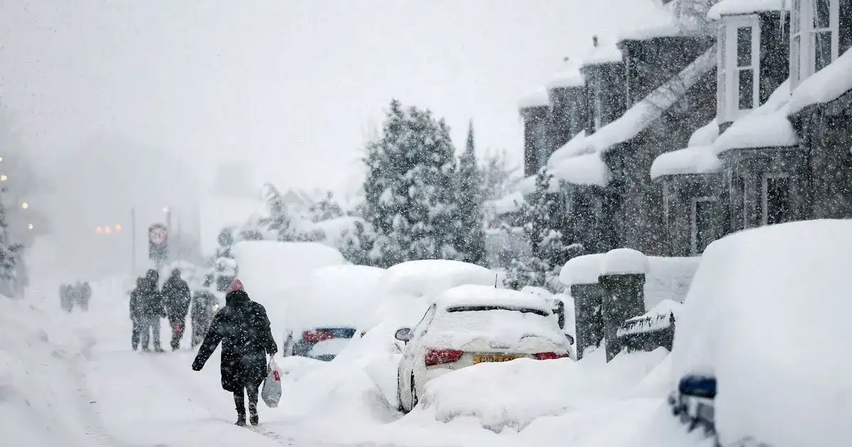
Multiple Met Office yellow warnings for snow and ice are in effect across the UK, with significant accumulations possible in higher elevations and risks of travel disruption. Temperatures are expected to plummet, leading to icy conditions on untreated surfaces.
The current weather pattern, influenced by an Arctic air mass, brings a considerable risk of wintry precipitation, including rain, sleet, and snow. Several regions are under active warnings, prompting public advisories for caution during travel and outdoor activities.

Context: A Series of Weather Warnings
Over the past few days, the Met Office has issued and updated a series of yellow weather warnings for snow and ice across various parts of the United Kingdom. These warnings signify a moderate risk of disruption and potential for some impact on daily life.
February 16 onwards: A 19-hour snow and ice warning began on February 16 at 3pm and extends until 10am on February 17, affecting five regions initially, later expanded to eleven areas.
Sunday Evening into Monday: An ice warning was in effect from 8pm on Sunday evening until 10am on Monday, covering parts of Scotland and North East England.
Friday into Saturday (past warning): A snow and ice warning for northern England and Scotland was in force from 9pm on Friday into Saturday morning. Another yellow warning for snow and ice was active for Scotland from 4pm on Thursday until midday on Friday, with a similar warning for northern England during the same period.
Ongoing: Yellow warnings for snow and ice continue to be issued, with specific timings and durations varying by region.
These warnings are being issued against a backdrop of an Arctic Maritime air mass bringing colder conditions southward.
Read More: BRITAIN DROWNS: Blocked Jet Stream Unleashes Endless Deluge!
Evidence of Wintry Conditions and Warnings
Official advisories and media reports detail the nature and scope of the impending weather events:
Snowfall Accumulation:
Up to 8cm (approximately 3 inches) of snow is forecast on ground above 300 meters, with 1-2 cm possible at lower levels.
Higher elevations, such as over 200 meters, could see 5-10 cm, and over 300 meters, potentially 15-20 cm.
Blizzard conditions and up to nine inches of snow are predicted for the west coast of Scotland and northern England.
Timing and Duration:
The primary 19-hour warning commenced on February 16 at 3pm and concluded at 10am on February 17.
Specific warnings have been active or are scheduled across different days, with durations often spanning overnight periods.
Affected Areas:
Initial warnings covered 5 regions, later expanded to 11 areas, including:
Central, Tayside and Fife (Angus, Perth and Kinross, Stirling)
Grampian (Aberdeen, Aberdeenshire, Moray)
Highlands and Eilean Siar
Orkney and Shetland
Strathclyde (Argyll and Bute)
Other areas affected by various warnings include North East England, South West Scotland, Lothian Borders, and parts of Wales.
Wind Conditions: Gusts could reach 60 mph in more exposed areas.
Impacts:
"Medium likelihood and low impact" is noted for icy patches on untreated roads, pavements, and cycle paths.
Potential for "some injuries from slips and falls on icy surfaces."
"Disruption to transport routes" is a recurring concern.
Snowfall and Ice: Regional Focus
Scotland: The Epicenter of Wintry Weather
Scotland is identified as a primary region for the heaviest snow and ice.

Warnings specifically target northern Scotland and extend to North East England.
Central Scotland is anticipated to experience temperatures as low as -4°C overnight.
The west coast of Scotland and northern England are bracing for blizzard conditions.
Warnings have been issued for areas like Central, Tayside & Fife, Grampian, Highlands & Eilean Siar, Orkney and Shetland, and Strathclyde.
Northern England: Facing Cold Snap Impacts
Parts of northern England are also under direct snow and ice warnings.
A yellow snow and ice warning has been in place for northern England.
Warnings have covered North East England and North West England.
Areas such as Northumberland are listed under ice warnings.
Other Affected Regions
Wales: An ice warning was set to expire on Saturday morning, and a separate ice warning affected Wales, South West England, and the East Midlands.
Midlands: The East Midlands and West Midlands were covered by a UK Health Security Agency (UKHSA) cold-health alert.
Risk of Disruption and Public Safety
The Met Office has categorized the likelihood and impact of some weather events.

Medium Likelihood, Low Impact: The possibility of icy patches on untreated surfaces and potential injuries from slips and falls are assessed as medium likelihood with low impact.
Travel Disruption: Warnings explicitly mention the likelihood of travel disruption due to snow, ice, and strong winds.
Cold-Health Alert: A UK Health Security Agency (UKHSA) cold-health alert was in place across several regions, highlighting the risks associated with plunging temperatures.
Expert Analysis on Weather Patterns
The Met Office provides official explanations for the prevailing weather conditions.
"An Arctic Maritime air mass is bringing colder conditions from the north of Scotland southwards." - Met Office
This indicates a significant shift in weather patterns, bringing more severe wintry conditions from polar regions.
Findings and Implications
The consistent issuance of yellow weather warnings for snow and ice by the Met Office indicates a period of challenging weather across multiple UK regions.
Geographic Extent: Warnings cover significant portions of Scotland and parts of Northern England, with broader ice warnings impacting other areas.
Severity: While classified as yellow warnings (indicating potential disruption), forecasts include accumulations of snow on higher ground, wind gusts, and sub-zero temperatures.
Public Advisory: Residents in affected areas are advised to be aware of potentially hazardous travel conditions and the risk of icy surfaces.
The situation underscores a continued spell of wintry weather influenced by cold air originating from the Arctic.
Sources Used
Met Office Issues 19 Hour Snow Warning for 5 Regions - Full List: https://www.express.co.uk/news/weather/2171414/met-office-snow-warning-uk-weather
UK Weather Warnings (Met Office): https://weather.metoffice.gov.uk/warnings-and-advice/uk-warnings
Met Office Names 11 Areas Facing Snow on Tuesday - Full List: https://www.express.co.uk/news/weather/2171428/met-office-names-uk-areas-snow-tuesday-weather
Met Office Issues 19-Hour Snow Warning as 11 Places Face Three Inches: https://www.mirror.co.uk/news/uk-news/breaking-met-office-snow-forecast-36728475
UK weather: Temperatures to drop as more warnings come into force: https://www.bbc.com/weather/articles/clyx2x85qdvo
Full List of UK Areas Affected by New Met Office 14-Hour Ice Warning: https://www.manchestereveningnews.co.uk/news/uk-news/full-list-uk-areas-affected-33430264
Met Office issues yellow weather warning as snow and rain to hit UK: https://www.independent.co.uk/news/uk/home-news/met-office-weather-forecast-uk-snow-rain-latest-b2921110
Snow warnings updated (Met Office): https://www.metoffice.gov.uk/about-us/news-and-media/media-centre/weather-and-climate-news/2024/snow-warnings-updated
Met Office issues yellow weather warning as snow and rain to hit UK: https://www.independent.co.uk/news/uk/home-news/met-office-weather-forecast-uk-snow-rain-latest-b2921110
UK weather warnings for snow in place as Met Office says travel disruption likely: https://www.independent.co.uk/news/uk/home-news/snow-weather-forecast-met-office-b2919654
Met Office issues new snow warnings as Brits brace for blizzard battering: https://www.dailystar.co.uk/news/latest-news/met-office-issues-new-warning-36725382
Warnings and advice (Met Office): https://www.metoffice.gov.uk/weather/warnings-and-advice
Met Office Issues Yellow Ice Warning Amid Arctic Blast: https://britbrief.co.uk/weather/radar/uk-ice-warning-issued-as-arctic-blast-hits-with-sub-zero-temperatures.html
Met Office UK ice warning as temperatures plummet in Arctic blast: https://www.examinerlive.co.uk/news/uk-world-news/met-office-uk-ice-warning-33430581
Heavy snow on way as Met Office issues yellow weather warning: https://www.dailymail.co.uk/news/article-15559845/Six-inches-snow-Met-Office-yellow-warning.html
An 'Arctic air mass' is bringing snow to the UK - this is what the Met Office is saying: https://news.sky.com/story/cold-weather-health-alert-issued-as-met-office-warns-of-snow-and-ice-13506958
Met Office issues fresh snow and ice weather warnings for large parts of UK: https://www.independent.co.uk/weather/snow-weather-warnings-met-office-uk-b2921128

