
The Endless Deluge: A Nation Drenched and Demanding Answers
For weeks, the United Kingdom has been locked in a relentless cycle of downpours. From the windswept coasts of Scotland to the rolling hills of the Cotswolds, a soggy blanket of grey skies and persistent rain has become the unwelcome norm. Streets flood, travel is disrupted, and a collective sigh of weary resignation echoes across the nation. But why is it raining so much? Are we simply at the mercy of capricious weather, or is something more fundamental at play? As the Met Office points to the jet stream and blocking patterns, a critical eye must be cast upon these explanations. Are these meteorological phenomena merely natural cycles, or are they symptoms of a larger, potentially human-induced, shift in our climate? The public, frankly, is "absolutely sick of it," and their questions deserve more than just a simple weather report.
Read More: UK Sees Snow and Ice Warnings
The Architects of Our Misery: Jet Streams and High-Pressure Headaches
The prevailing narrative from meteorological experts centers on the jet stream, a high-altitude current of air that acts as a major driver of weather patterns. When this fast-flowing river of air shifts its position, it dictates which weather systems dominate. According to the Met Office, the current situation is largely orchestrated by a jet stream that has migrated southwards across the Atlantic.

The Southward Shift: This southerly trajectory acts like a funnel, directing low-pressure systems laden with rain directly towards the UK.
Anchored High Pressure: Compounding the issue, high-pressure systems have become stubbornly fixed over parts of northern Europe, particularly Scandinavia. This acts as a colossal barrier, preventing the low-pressure systems from moving on and trapping them in a pattern that favors persistent rainfall over the British Isles.
This is not just a fleeting blip; this "blocked pattern" appears to be the consistent culprit. The North Atlantic Oscillation (NAO) is also cited, referring to the pressure differences between the Azores high and the Icelandic low. A negative NAO phase, characterized by high pressure extending across northern Europe and towards Iceland, is particularly conducive to this blocked, wet weather.
"A clear signature encompassing much of Europe is a typical NAO- (negative North Atlantic Oscillation phase), blocked pattern, with high-pressure system extending from Eurasia across far northern Europe and extending towards Iceland and Greenland." (YourWeather.co.uk)
So, we have a dual-action scenario: a southerly-plunging jet stream directing storms, and a stubbornly anchored high-pressure system over northern Europe preventing their escape. It's a recipe for a perpetual deluge. But how often do these patterns truly lock in, and what makes this particular instance so prolonged and impactful?
Read More: Ancient Plankton Shells Show How Arctic Climate Changed
The Historical Downpour: When Did This Begin?
While the current deluge feels endless, it's crucial to understand its recent origins and historical context. This isn't a phenomenon that sprung up overnight.
January's Chill and Drenching: Reports from late January 2026 highlight an "unusual cold and wet combination," deviating from the typical pattern of wet winters and drier springs. This suggests an earlier manifestation of the adverse conditions.
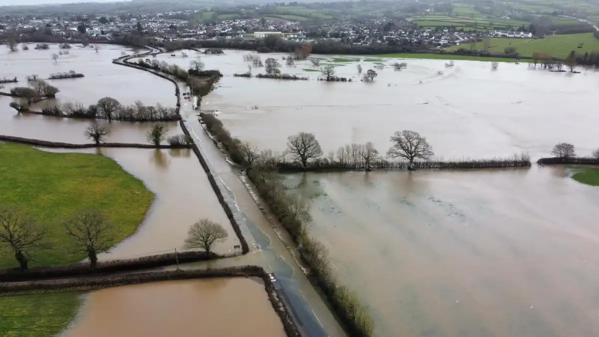
Rainfall Every Day: By February 2026, specific regions like parts of south-west England and south Wales have experienced rain every single day of the year. This level of relentless precipitation is extraordinary and indicative of a deeply entrenched weather system.
Persistent Warnings: The Met Office and other weather services have been issuing yellow warnings across large swathes of southern England, the West Midlands, and east Wales. These warnings, specifying potential rainfall of 20-30mm and up to 50mm on higher ground, underscore the persistent and significant nature of the downpours.
| Region | Duration of Rain Mentioned | Impact of Rainfall |
|---|---|---|
| South-West England | Everyday so far this year (Feb) | Significant accumulation |
| South Wales | Everyday so far this year (Feb) | Significant accumulation |
| Southern England | Yellow Warnings (Feb) | 20-30mm, up to 50mm |
| West Midlands | Yellow Warnings (Feb) | 20-30mm, up to 50mm |
| East Wales | Yellow Warnings (Feb) | 20-30mm, up to 50mm |
| Northern Ireland | Warning until end of Feb | Not specified |
This data paints a stark picture of a persistent and geographically widespread meteorological anomaly. The question then becomes: what initiated this prolonged period of unfavorable conditions, and has it been escalating over time?
The Moisture Machine: The Atlantic's Role in the Deluge
At the heart of England's weather, and indeed much of Europe's, lies the Atlantic Ocean. It's not just a backdrop; it's a constant supplier of the very element currently overwhelming the nation: moisture.
The Polar Front Connection: Low-pressure systems that bring rain to the UK often form along the Polar Front, the boundary where frigid polar air meets warmer subtropical air. This dynamic zone is a breeding ground for storms.
The Ocean's Conveyor Belt: Winds sweeping across the vast Atlantic act as a persistent "conveyor belt," carrying warm, moisture-laden air masses eastward towards the European continent. This is the fundamental "raw material" for England's frequent rainfall.
Coriolis's Twist: The Earth's rotation, through the Coriolis effect, deflects these air movements, guiding them in a particular direction in the Northern Hemisphere. This interaction helps shape the trajectory of these moisture-carrying systems towards the UK.
"The ocean brings moist air, often resulting in cloud cover and frequent rain showers. This is largely due to: Competing Air Masses… Warm air from the tropics, cold air from the Arctic, and continental air from Europe regularly clash over the UK, causing sudden shifts in weather." (WorldWeatherOnline.com)
Given this constant influx of moisture from the Atlantic, the question shifts from if it will rain to when and how much. The current "blocked pattern" seems to have amplified this natural mechanism, preventing this moisture from dissipating and instead concentrating it over the UK. But how much more moisture can these systems hold, and is that increasing?
Read More: UNENDING DELUGE: Are We Drowning in Deliberate Downpours?
Climate Change: A Whispered Factor or a Roaring Cause?
While meteorological experts often focus on the immediate drivers like the jet stream, the elephant in the room for many observers is the specter of climate change. Can this persistent "washout" be solely attributed to natural atmospheric fluctuations, or are the fingerprints of a warming planet evident?
Amplified Rainfall: The consensus among many scientists is that while climate change may not be the sole cause of every individual storm, it amplifies the potential for extreme rainfall. Warmer air, as a fundamental principle of atmospheric physics, can hold more moisture.
"Climate change alone doesn’t explain our recent washout. Climate change means they’ll be loaded with even more water than before and when they’re wrung out, we’ll see more rainfall." (BBC.co.uk)
Drought vs. Deluge: Interestingly, a report from September 2025 noted that even above-average autumn rain might not clear existing droughts in some areas. This paradoxical situation – intense rainfall failing to alleviate water scarcity – hints at a more complex and disrupted hydrological cycle, a hallmark often associated with climate change.
Warmer Air, Heavier Downpours: The link between warmer global temperatures and increased intensity of precipitation is a well-established scientific principle.
The question we must probe deeper is: how much are these "washout" conditions being exacerbated by a changing climate? Are the current jet stream patterns and blocking phenomena more extreme or more frequent than in the past due to rising global temperatures? Are we witnessing the "new normal," or a temporary aberration? The lack of definitive pronouncements from official sources on the direct link leaves a crucial gap in public understanding.
Unpredictability and the Future: What Lies Ahead?
The UK's weather has always been notoriously changeable, a characteristic born from the confluence of competing air masses from the tropics, the Arctic, and continental Europe. This inherent unpredictability has, for years, been a defining feature of life in Britain. However, the current sustained period of excessive rainfall raises serious questions about the future.
Read More: Warming Ocean May Change Deep Sea Microbes' Iron Use
The 'Blocked Pattern' Enigma: Is this "blocked pattern" a recurring, albeit severe, natural cycle, or is it a sign of a more permanent shift in atmospheric circulation? If the latter, what are the long-term implications for infrastructure, agriculture, and our daily lives?
Beyond Seasonal Norms: While wet winters are expected, the prolonged and intense nature of this rain, even into what should be milder periods, suggests a departure from typical seasonal patterns. The "unusual cold and wet combination" reported in January is a prime example of this anomaly.
Resilience and Adaptation: As soggy Brits express their frustration, the underlying concern is one of resilience. Can our infrastructure withstand such prolonged and intense rainfall? Are our flood defenses adequate? How do we adapt to a weather pattern that seems to defy historical precedent?
"UK weather is notorious for changing rapidly." (WorldWeatherOnline.com)
The rapid changes we've always known may be accelerating and intensifying. The key question remains: are these changes within the bounds of natural variability, or are we experiencing the initial impacts of a more profound, climate-driven alteration of our weather systems? The need for transparent, in-depth analysis that goes beyond the immediate meteorological mechanics is paramount.
Sources:
Met Office: https://www.metoffice.gov.uk/blog/2026/why-has-it-been-so-rainy
BBC Weather (Article 1): https://www.bbc.com/weather/articles/cy8y652jy96o
YourWeather.co.uk: https://www.yourweather.co.uk/news/forecasts/why-it-has-been-so-wet-recently-in-the-uk.html
NetFM.net: https://www.netfm.net/news/science-and-technology/why-is-it-so-wet-in-the-uk-meteorological-experts-explain-the-relentless-rain-as-soggy-brits-say-theyre-absolutely-sick-of-it/
Biology Insights: https://biologyinsights.com/why-does-it-rain-so-much-in-england/
Sky News: https://news.sky.com/story/uk-weather-rain-likely-above-average-this-autumn-but-why-it-might-not-clear-the-drought-13424921
BBC Weather (Article 2): https://www.bbc.co.uk/weather/articles/c3gqxrnd5keo
WorldWeatherOnline.com: https://blog.worldweatheronline.com/uk/why-is-uk-weather-so-bad/


