
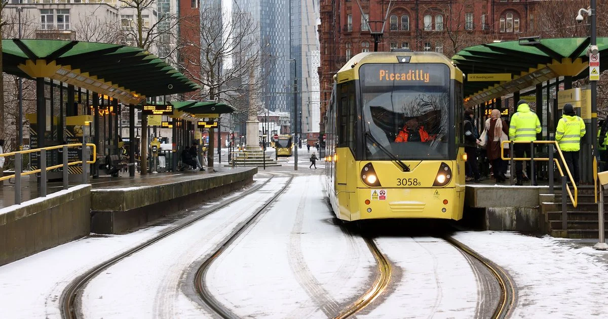
Cold air sweeping across the United Kingdom has prompted the Met Office to issue several snow and ice warnings, impacting Greater Manchester and other regions. Forecasters anticipate wintry conditions, including snowfall and icy surfaces, with specific concerns raised for travel disruption. The advisability of heeding these warnings is paramount for those in affected areas.
Meteorological Context and Timeline
Recent weather patterns indicate a shift towards colder temperatures, with the Met Office issuing multiple advisories for snow and ice. These warnings are not isolated events but part of a broader meteorological trend affecting various parts of the UK.
Early February: Wintry conditions began to appear, particularly in northern areas of the UK. Snowfall was observed on higher ground in parts of Greater Manchester on February 4th, prompting an earlier snow and ice warning.
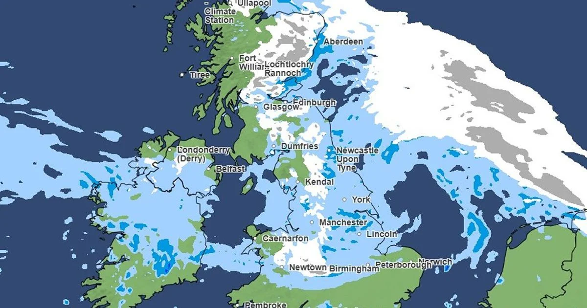
Mid-February: A significant "800-mile wall of snow" was projected to move across the UK.
Thursday, February 12th: Yellow warnings for snow and ice came into effect.
7 PM: Warnings began for parts of North West England, including Greater Manchester, and extended to other regions like North East England and Scotland.
9 PM: Snow showers were predicted to start in specific areas of Greater Manchester, such as Rochdale and Tameside.
Thursday night into Friday, February 13th: Snowfall was expected to continue, potentially causing travel disruption.
Warnings for Greater Manchester concluded at 12 PM on Friday, February 13th.
Warnings for Scotland also ended at 12 PM on Friday, February 13th.
Friday, February 13th: Wintry weather was forecast to continue across much of the region, with snow and sleet expected, especially to the east and north of Greater Manchester.
Saturday, February 14th into Sunday, February 15th: Further snowfall was anticipated as the large band of snow was expected to cross the UK. Weather maps indicated this "snow wall" would pass eastwards.
Earlier Forecasts: As early as late January, Met Office maps suggested possible snow in parts of Greater Manchester from January 26th and specifically mentioned snow on hills in Scotland on January 23rd. Forecasts from two weeks prior also indicated a return of wintry conditions during the first two weeks of February.
Scope of Warnings and Expected Accumulations
The Met Office has issued yellow weather warnings for snow and ice, signifying a moderate risk of disruption. These warnings have covered extensive geographical areas.
Read More: Cold Air Brings Snow and Ice Warnings to the UK
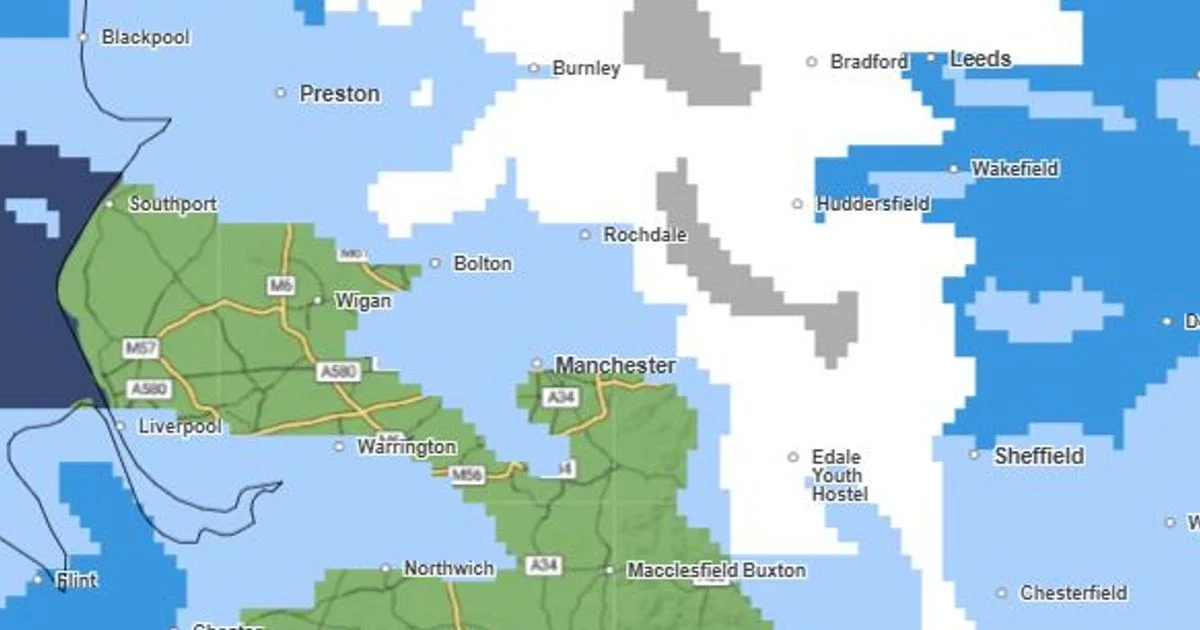
Greater Manchester: Warnings have specifically targeted areas within Greater Manchester.
Broader UK Impact: Warnings have been in place across large parts of England, Scotland, Wales, and Northern Ireland at various times.
Snowfall Predictions:
Up to 10cm of snow is possible in some areas, particularly on higher ground (above 300 metres).
2-5cm of snow is possible above 200 metres.
1-2cm is expected more widely in Scotland.
Sleet and Ice: Sleet showers and icy surfaces on untreated roads and pavements are also anticipated, contributing to potential travel difficulties.
Key Actors and Entities
Met Office: The national meteorological service responsible for issuing weather forecasts and warnings in the UK.
Greater Manchester Residents and Authorities: Those directly affected by the warnings and responsible for public safety and infrastructure.
General Public: Individuals travelling or undertaking activities where weather conditions may pose a risk.
Evidence of Wintry Conditions
Met Office weather maps have been a primary source for visualizing and predicting the movement and intensity of snow. Reports detail specific timings and expected accumulations.
Read More: West Ham Fans Show They Are Unhappy with Owners
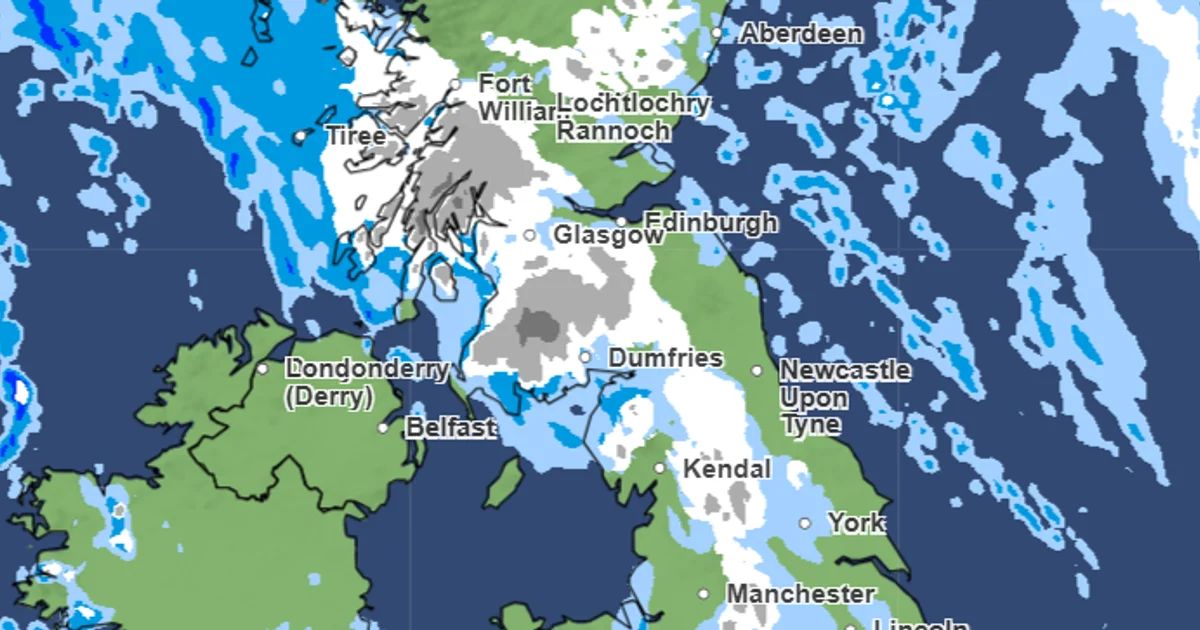
Met Office maps depict a large, approximately 800-mile band of snow pushing eastwards across the UK. (Article 2, 10)
Specific warnings were issued for Greater Manchester, including one that began at 7 PM on Thursday, February 12th, and ended at 12 PM on Friday, February 13th. (Article 6, 16)
Snow showers were anticipated from around 9 PM on Thursday in areas like Rochdale and Tameside. (Article 4)
The Met Office has also issued cold health alerts for the North West, indicating plummeting temperatures. (Article 5)
Potential Impacts and Advisories
The primary concern highlighted by the Met Office and reported in the articles is the potential for travel disruption.
Snow showers and icy roads could lead to travel disruption in affected areas. (Article 10)
Advisories have stressed allowing extra time for travel, both on roads and on foot. (Article 12)
Icy patches are expected on untreated roads, pavements, and cycle paths. (Article 15)
The warnings indicate that rain is expected to turn to snow over hills, potentially leading to travel disruption. (Article 13)
Expert Insights on Wintry Weather Patterns
The Met Office's warnings are based on meteorological analysis of prevailing weather systems. Reports indicate a shift from previous unsettled, wet conditions to colder air.
Read More: Satellites Show Lots of Snow and Ice in North America
The current forecasts follow a period of record-breaking wet weather across the UK. (Article 2)
Cold air is described as sweeping in, increasing the likelihood of wintry showers. (Article 5)
The shift to 'Atlantic-dominated conditions' was anticipated from Sunday, February 15th, with rain, strong winds, and snow forecast for northern areas. (Article 12)
Analysis of Snowfall and Ice Risk
While snow warnings have been widespread, the severity and exact location of snowfall have varied.
Higher Ground Versus Lower Elevations
Higher Ground: Reports consistently indicate that snow is expected to settle more significantly on higher ground, particularly to the north and east of Manchester, and in areas above 200 and 300 metres. Up to 10cm is possible in these locations. (Article 11, 16)
Lower Elevations: In contrast, sleet showers and icy conditions are noted as being more pertinent to lower-lying areas like Manchester itself. (Article 6, 8)
Timing and Duration of Snowfall
The precise timing and duration of snowfall have been subject to specific warnings.
Read More: Epstein Jet Logs Show 90 Trips to Britain
Overnight Thursday into Friday: A significant warning period for Greater Manchester ran from 7 PM Thursday to 12 PM Friday, with snow showers expected to continue into the early hours and early morning. (Article 4, 6, 16)
Weekend Snowfall: A larger "snow wall" was predicted to move across the UK over the weekend of February 14th-15th, with further snowfall expected in Greater Manchester during the early morning hours of Sunday. (Article 2, 16)
Distinction Between Snow and Ice Threats
The warnings encompass both snow and ice, though the emphasis of the threat can differ geographically.
Snow Threat: Primarily concentrated on higher ground and specific northern and eastern parts of the UK.
Ice Threat: Described as more pertinent to Manchester itself, with warnings about icy patches on untreated surfaces. (Article 6, 8, 15)
Conclusion and Outlook
The Met Office has issued several yellow warnings for snow and ice across Greater Manchester and other parts of the UK in mid-February. These warnings are based on incoming cold air and predicted snowfall, with particular emphasis on potential travel disruption due to snow accumulations and icy surfaces.
Read More: Portugal Faces Bad Storms, Shows Weak Spots in Buildings and Roads
Key Findings:
Snowfall is expected, with accumulations potentially reaching 10cm in some higher areas.
Icy conditions are a significant concern, especially for untreated surfaces.
Warnings have been issued with specific start and end times, impacting different regions at different times.
The largest snowfall event predicted was an 800-mile "snow wall" moving across the UK over the weekend of February 14th-15th.
Implications: Residents and travellers in affected areas should remain aware of the latest Met Office updates, plan journeys accordingly, and take precautions against the cold and icy conditions.
Next Steps: Continued monitoring of weather forecasts and adherence to official guidance from the Met Office are advised for individuals in regions subject to these warnings.
Sources
Met Office issues snow weather warning for Greater Manchester as 10cm forecast
Link: https://www.manchestereveningnews.co.uk/weather/met-office-issues-snow-weather-33402310
Context: Published 3 days ago, reporting on snow and ice warnings for Greater Manchester with predicted accumulations.
Exact time snow is forecast in Greater Manchester as 800-mile snow wall to hit UK
Link: https://www.manchestereveningnews.co.uk/weather/snow-forecast-greater-manchester-uk-33401863
Context: Published 3 days ago, detailing the timing of snow for Greater Manchester and the larger UK "snow wall" event.
Met Office UK weather maps show where and when snow will hit this week
Link: https://www.manchestereveningnews.co.uk/news/uk-news/met-office-uk-weather-maps-33343325
Context: Published 2 weeks ago, providing an early outlook on wintry conditions returning to the UK.
Met Office maps show exact time snow is forecast in Greater Manchester TONIGHT
Context: Published 2 days ago, focusing on specific timings of snow showers for Greater Manchester on Thursday evening.
Everything we know about snow forecast in Greater Manchester
Link: https://www.manchestereveningnews.co.uk/weather/everything-know-snow-forecast-greater-33291900
Context: Published 3 weeks ago, an early report indicating possible snow and cold health alerts.
Met Office issues new verdict as maps show snow across Greater Manchester
Link: https://www.manchestereveningnews.co.uk/news/uk-news/met-office-issues-new-verdict-33414813
Context: Published 2 days ago, detailing a yellow snow and ice warning for Greater Manchester and other UK regions.
Met Office maps show when snow could hit Greater Manchester again this week
Context: Published 1 week ago, reporting on potential wintry conditions in Greater Manchester and warnings in effect earlier in the week.
Met Office latest for Greater Manchester as snow and ice warning in force
Context: Published 1 day ago, providing an update on an active snow and ice warning for Greater Manchester.
Met Office maps forecast snow in Greater Manchester as cold snap to grip UK
Link: https://www.manchestereveningnews.co.uk/weather/met-office-maps-reveal-snow-33282547
Context: Published 3 weeks ago, an early forecast for snow across hills in the UK and Greater Manchester.
Met Office warning as maps show blanket of white to hit UK in 800-mile snow wall
Link: https://www.manchestereveningnews.co.uk/weather/snow-maps-weather-met-office-33411206
Context: Published 2 days ago, discussing Met Office yellow warnings and the 800-mile snow wall event.
All the 60 UK areas affected by Met Office snow weather warning - full list
Link: https://www.manchestereveningnews.co.uk/weather/60-uk-areas-affected-met-33402409
Context: Published 3 days ago, providing a comprehensive list of areas under Met Office snow and ice warnings.
Brits braced as snow start to fall with warning issued for entire country
Link: https://www.mirror.co.uk/news/uk-news/uk-snow-weather-maps-live-36720821
Context: Published 5 hours ago, a live report on snow falling and warnings across the UK.
Everything we know about Met Office forecast for snow in Greater Manchester
Link: https://www.manchestereveningnews.co.uk/news/uk-news/everything-know-met-office-forecast-33370076
Context: Published 1 week ago, detailing a specific yellow snow warning for parts of Greater Manchester in early February.
When and where it will snow this week as wintry weather to grip UK
Link: https://www.manchestereveningnews.co.uk/weather/snow-week-wintry-weather-grip-33409866
Context: Published 2 days ago, explaining where and when snow was expected to fall across the UK.
Met Office Yorkshire snow warning as 23 parts of England covered from Thursday
Link: https://www.examinerlive.co.uk/news/uk-world-news/met-office-yorkshire-snow-warning-33404286
Context: Published 3 days ago, focusing on a yellow warning for snow and ice affecting parts of England.
Everything to know about snow warning for Greater Manchester
Link: https://www.manchestereveningnews.co.uk/weather/everything-know-snow-warning-greater-33406736
Context: Published 3 days ago, a detailed overview of a snow and ice warning for Greater Manchester.
Read More: Fewer People Coming to UK May Hurt Economy


