
Recent satellite observations confirm extensive snow and ice cover across significant portions of North America. Multiple imaging instruments have captured images depicting these conditions, offering a clear visual representation of winter's reach. This data is crucial for understanding weather patterns, resource management, and the impacts of these phenomena.
Data from satellites like the Visible Infrared Imaging Radiometer Suite (VIIRS) and the Moderate Resolution Imaging Spectroradiometer (MODIS) are regularly used to map snow and ice. These instruments distinguish snow and ice from other surfaces, including clouds, based on their distinct reflectivity.
Widespread Winter Conditions Documented
Recent reports detail substantial snow accumulations and widespread ice across various regions.
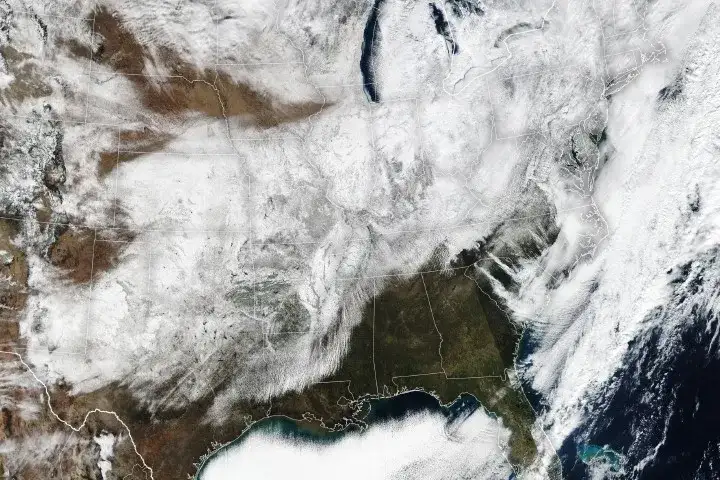
On January 26, VIIRS aboard the Suomi NPP satellite captured images showing new snow covering a large part of the United States.
Some areas experienced record-breaking daily snowfall, with 5.1 inches recorded in St. Louis, Missouri, on January 24, and 11.2 inches in Pittsburgh, Pennsylvania, on January 25.
Preliminary National Weather Service data indicated accumulations of up to 12 inches in parts of Oklahoma between January 23 and 26, with higher amounts in the Midwest and New England.
Heavy snow, coupled with extreme cold, sleet, and ice, led to difficult travel, power outages, and school closures.
North Texas also saw several inches of snow and sleet, a less common occurrence for the region.
In February 2021, satellite images indicated that nearly the entire United States was blanketed in snow, with three-quarters of the country covered. This event was linked to a deadly winter storm that left millions without power.
A significant nor'easter in February 2013 deposited snow from the East Coast westward past the Great Lakes, with a band of snow extending south into West Virginia.
In January 2022, a powerful nor'easter brought over 14 inches of snow to parts of southern Virginia and southern Maryland, disrupting transportation, including Interstate 95.
Satellite Systems and Data Collection
Various satellite systems are employed to monitor snow and ice cover globally and regionally.

NASA's MODIS instruments, on the Terra and Aqua satellites, provide daily global snow cover data, enabling scientists to differentiate snow from clouds due to their contrasting brightness. This allows for the estimation of water content in snowpacks, a vital resource in regions like the western United States.
NOAA satellites, specifically the Geostationary Operational Environmental Satellites (GOES), are utilized for tracking weather systems, including low-pressure systems and associated warnings for cold, ice, and winter storms.
The U.S. National Ice Center also contributes data through its satellite observations.
Satellite instruments are adept at identifying snow and ice due to their high reflectivity, which contrasts with most natural surfaces.
Read More: Mumbai Red Alert July 2026 Causes School Closures and Train Delays
Regional and Hemispheric Snow Cover Extent
Data visualizations and maps are available to show the extent of snow and ice across North America and the Northern Hemisphere.
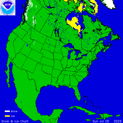
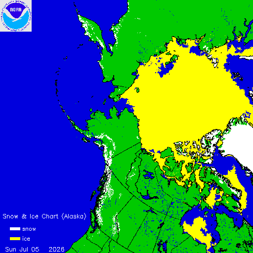
Daily maps from sources like the U.S. National Ice Center illustrate snow cover over the contiguous United States, Alaska, and the entire Northern Hemisphere.
Websites like NOHRSC (National Operational Hydrologic Remote Sensing Center) provide current and recent graphics of snow cover extent based on satellite observations.
Visualizations of snow and ice extent are also offered for specific regions, including Alaska, Western Canada, and Eastern Russia.
The extent of snow cover in the U.S. and the Northern Hemisphere is mapped using satellite data, with resources available for current and archived information.
The Significance of Snow Cover Data
Snow cover plays a substantial role in various environmental processes and resource management.
Snow on the ground influences biological, chemical, and geological processes.
In many areas, snow cover represents a critical water resource. Scientists use satellite data to estimate water content from snow melt runoff, which is essential for human consumption and irrigation.
Changes in land cover, including the decrease in snow and ice, are monitored by remote sensing.
Conflicting or Nuanced Perspectives
While the presence of snow and ice is clearly visible via satellite, the interpretation and implications can vary.
Impact on Daily Life: News reports frequently highlight the disruptive effects of heavy snow and ice, such as treacherous travel, power outages, and widespread school closures. These events underscore the immediate challenges posed by severe winter weather.
Resource Value: From a resource perspective, snowpack is a vital source of fresh water, particularly in western U.S. regions. Satellite monitoring helps in predicting water availability.
Long-Term Environmental Changes: Broader analyses of land cover changes, which include shifts in snow and ice extent, are part of ongoing scientific research. This perspective often examines trends over longer periods.
Conclusion
Satellite imagery and data from instruments like VIIRS and MODIS provide a consistent and objective record of snow and ice cover across North America and the Northern Hemisphere. These observations are vital for weather forecasting, climate monitoring, and water resource management. The documented instances of widespread snow and ice demonstrate the significant impact of winter weather events, highlighting both the challenges they present and their role in the Earth's systems. Continued monitoring through these remote sensing technologies is essential for a comprehensive understanding of these phenomena.
Read More: World Cup 2026 travel rules block teams and referees in April 2026
Sources Used:
Article 1: Snow and Ice Cover - Map Viewer
Type: Data Resource / Map Viewer
Description: Provides daily maps and animations of snow and ice extent using satellite data.
Link: https://www.climate.gov/maps-data/dataset/snow-and-ice-cover-map-viewer
Article 2: Snow Buries the U.S. Interior and East - NASA Science
Type: News Report / Feature Article
Description: Details recent significant snowfall events across the U.S. observed by the VIIRS satellite.
Link: https://science.nasa.gov/earth/earth-observatory/snow-buries-the-u-s-interior-and-east/
Article 4: MODIS Snow / Ice Global Mapping Project
Type: Data Resource / Project Information
Description: Discusses the role of remote sensing and the MODIS project in mapping snow cover and its influence.
Article 5: Northern Hemisphere Snow Cover - NOHRSC - The ultimate source for snow information
Type: Data Resource / Information Hub
Description: Offers current and recent graphics of snow cover extent in the U.S. and Northern Hemisphere from satellite observations.
Article 6: Satellite Mappers Have North America Covered - NASA Science
Type: News Report / Feature Article
Description: Discusses remote sensing for land cover, including snow and ice, across North America.
Link: https://earthobservatory.nasa.gov/images/148087/satellite-mappers-have-north-america-covered
Article 7: These satellite images show almost the entire US covered in snow
Type: News Report
Description: Reports on a major winter storm in February 2021, showing near-total U.S. snow cover via satellite imagery.
Link: https://www.businessinsider.com/us-covered-in-snow-satellite-images-2021-2
Article 8: Snow across the Northeastern United States - NASA Science
Type: News Report / Feature Article
Description: Describes a snow event in February 2013 impacting the northeastern U.S., as captured by NASA's Aqua satellite.
Link: https://earthobservatory.nasa.gov/images/80403/snow-across-the-northeastern-united-states
Article 9: NOAA Satellites Monitor Massive Winter Storm
Type: News Report / Press Release
Description: Highlights the role of NOAA satellites in monitoring a significant winter storm.
Link: https://www.nesdis.noaa.gov/news/noaa-satellites-monitor-massive-winter-storm
Article 10: Winter Snow Cover in the Northern Hemisphere - NASA Science
Type: News Report / Feature Article
Description: Explains NASA's MODIS satellite's role in measuring global snow cover and its importance as a water resource.
Link: https://earthobservatory.nasa.gov/images/2657/winter-snow-cover-in-the-northern-hemisphere
Article 11: Satellite images show epic snowstorm that shut down part of Interstate 95
Type: News Report
Description: Details a January 2022 snowstorm affecting the Mid-Atlantic U.S., with images from NASA's Terra satellite.
Link: https://www.space.com/us-snowstorm-january-2022-satellite-images
Article 12: Northern Hemisphere and North America Snow and Ice Chart
Type: Data Resource / Chart Provider
Description: Provides access to snow and ice maps for the Northern Hemisphere and North America.


