At least six people are dead following a series of atmospheric collapses across the American Heartland between March 5 and March 7. The wreckage is split between Michigan—where four people died, including a 12-year-old boy—and Eastern Oklahoma, where two others were killed. Survey teams from the National Weather Service (NWS) are currently walking through the splintered remains of Major County and the Union Lake area to decide if the wind rotated enough to earn the official label of a tornado.
“As of right now, we're still investigating that.” — Ryan Bunker, Meteorologist, National Weather Service.
The distinction between a "straight-line wind" and a "tornado" remains a technicality for those buried under the debris. While the agency in Norman, Oklahoma prepares its damage surveys, the immediate reality is a jagged landscape of slab and scrap metal.
Casualties and Regional Impact
The geography of the dead is scattered, linked only by the movement of a cold front pushing against warm, wet air.
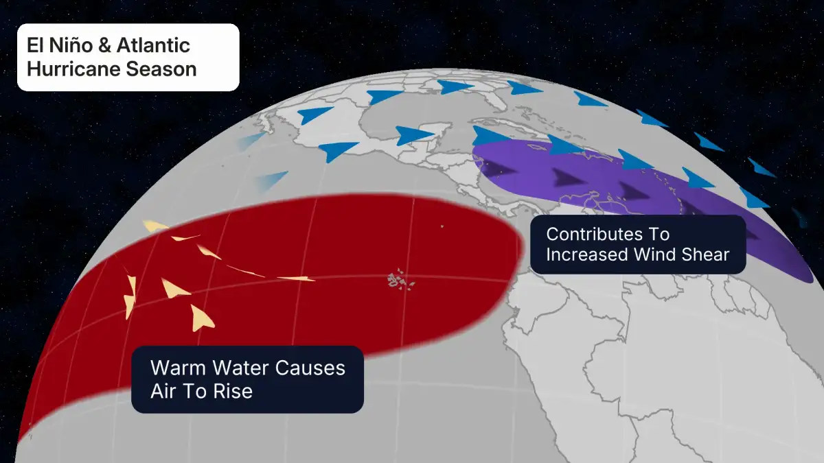
Read More: El Niño May Come to Australia, Weather May Change

| Location | Deaths | Key Detail |
|---|---|---|
| Branch County, MI | 3 | Deaths occurred in the Union Lake area; 12 injured. |
| Cass County, MI | 1 | A 12-year-old boy died; several others sustained injuries. |
| Eastern Oklahoma | 2 | Authorities searching rubble in rural prairies. |
| Major County, OK | Storm hit at 10 p.m. Thursday; heavy structural damage. |
The Cass County Sheriff’s Office confirmed the child's death roughly 50 miles southwest of the Union Lake site, indicating a wide, erratic path of destruction.
In Oklahoma, the storm struck the prairie late Thursday night, around 10 p.m., forcing a transition from local emergency management to recovery as the sun rose Friday.
Secondary effects of the system reached the Northeast, where a mix of rain and slush stalled transit in Pennsylvania, Maine, and Connecticut, though these areas avoided the lethal velocities seen in the Midwest.
The weather system functioned as a kinetic surge, turning ordinary building materials into projectiles before losing energy over the Ozarks.
The Institutional Gaze
State and local officials treat the arrival of lethal weather as a predictable cycle, often referred to as a "season." This framing suggests a level of control or expectation that the actual physics of the storms rarely respect.
Melissa Mayes, of Washington County Emergency Management, noted this was the "first real event" of the season, suggesting a psychological shift for a population that largely ignores the sky until the sirens trigger.
Governor Kevin Stitt remains in a posture of investigation, waiting for federal or local agencies to provide a final tally of the structural and human cost.
The NWS continues to rely on ground-truth observation to validate their radar models, a process that happens only after the harm is done.
Context of the Collapse
These storms are part of a broader low-pressure system that moved from the Plains toward the Midwest. While the immediate threat has shifted eastward into the Ozarks and toward the Atlantic, the internal mechanics of the March 5-6 events suggest an early start to high-energy atmospheric disturbances in the central corridor.
The Winter Weather Advisories in the Northeast act as a quiet coda to the violence in the Heartland, showing how the same system can be merely an inconvenience in one zip code and a lethal force in another. The search for bodies in the Michigan rubble is expected to conclude as survey crews finalize their data.
Read More: Survivor Says Epstein Abused Her During House Arrest in Florida