
Key Findings
New research utilizing satellite observations indicates that methane, a potent greenhouse gas, is being removed from the Earth's stratosphere at a quicker pace than current scientific models suggest. This finding has implications for understanding the gas's atmospheric lifespan and its overall impact on global warming. While methane persists for about a decade before breaking down, its removal rate in the upper atmosphere appears to be accelerating beyond earlier projections.
Methane's Role in Climate
Methane is a significant contributor to climate change due to its strong heat-trapping abilities. Limiting human-caused methane emissions is seen as a fast-acting strategy to curb global warming, as methane breaks down in the atmosphere much faster than carbon dioxide. Unlike CO2, which can remain in the atmosphere for centuries, methane's atmospheric presence is typically around 10 years.
Read More: Cartoonist Rohan Chakravarty Uses Funny Pictures to Teach About Nature
Discrepancies in Stratospheric Methane Removal
A recent study from the University of Washington highlights a notable difference between observed stratospheric methane loss and model predictions. The stratosphere, the second layer of Earth's atmosphere, is where a portion of methane's breakdown occurs.
Satellite data has provided a new measure for methane removal in this layer.
This new measure suggests a faster rate of loss than previously estimated.
Model Simulation Biases Identified
Simulations of methane concentrations in the stratosphere may contain biases. These inaccuracies can lead to errors when trying to determine methane emissions using satellite data. The extent to which these stratospheric biases affect the calculated distribution of emissions, particularly at higher latitudes, appears to be substantial.
Tropical Wetlands and Recent Methane Surges
Recent increases in atmospheric methane have been significantly linked to heightened emissions from tropical inundated areas, such as wetlands.
Read More: AI Finds Sperm, Skin Cells Made Into Eggs for Fertility Help
These tropical sources appear to account for a large portion of the recent changes in the global atmospheric methane growth rate.
Satellite observations are proving valuable in evaluating year-to-year changes in methane emissions from these tropical regions.
Estimates of global methane emissions, including those from tropical wetlands and fires, are being refined through atmospheric observations and advanced inversion techniques using satellite data.
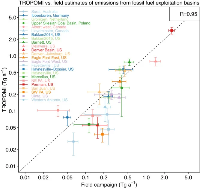
Satellite Data and Emission Inventories
Satellite instruments, like GOSAT and TROPOMI, have fundamentally changed how scientists understand methane budgets across the globe.
GOSAT data has been used to revise our understanding of regional methane budgets.
TROPOMI data offers higher spatial resolution, enabling the inference of diffuse methane emissions from sources like coal mining.
Scientists are integrating data from various sources, including satellite observations and in-situ measurements from networks like the NOAA Cooperative Global Air Sampling Network, to create a more coherent picture of changing methane emissions.
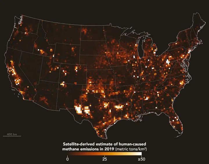
Underestimated U.S. Methane Emissions
Evidence suggests that methane emissions from the United States may be underestimated.
Read More: UK Winters Are Getting Wetter, Scientists Say
A NASA Science report points to satellite data indicating higher emissions than officially reported by some facilities.
Specifically, a subset of 70 high-emitting landfills across the U.S. showed median emissions that were 77 percent higher than their reported figures to the EPA.
These 10 states were responsible for a significant portion (55 percent) of U.S. human-caused methane emissions.
Quantifying Methane from Point Sources to Global Scales
Satellite observations are proving instrumental in quantifying methane emissions, from large-scale sources down to individual, high-emitting points.
Studies are using satellite data to detect high-emitting methane sources in areas like oil and gas fields.
Research has also focused on quantifying methane emissions from landfills and identifying specific point sources.
Techniques involve inversions of satellite observations, which help to constrain global methane emissions and sinks more accurately.
International Emission Inventories
Satellite observations are also being used to infer national methane emissions on a global scale.
Read More: New Ways to Help People Have Babies Using Science
This includes developing gridded inventories of anthropogenic methane emissions for countries like Canada.
High-resolution inversions of satellite observations are being applied to understand methane emissions from China, including rice cultivation.
Satellite-derived emissions from areas like inundation in Bangladesh are also being quantified.
These observations are used in conjunction with estimates provided by international bodies like the UNFCCC.
Expert Analysis
"The discrepancies between satellite observations and model simulations highlight areas where our understanding of atmospheric processes, particularly methane's stratospheric chemistry, needs refinement." - Anonymous atmospheric scientist
"The power of satellite remote sensing lies in its ability to provide a global perspective and identify emission hotspots that might be missed by ground-based networks alone. This is crucial for accurate emissions accounting." - Cited in Nature Communications
Conclusion
The recent findings from satellite observations underscore a critical need to re-evaluate current models of stratospheric methane removal. The observed accelerated loss rate suggests that methane may have a shorter effective atmospheric lifespan in the upper atmosphere than previously accounted for. This has potential implications for climate change projections and the efficacy of emission reduction strategies. Furthermore, satellite data continues to reveal discrepancies in reported emissions from various sectors and countries, indicating that global methane emissions may be systematically underestimated. The ongoing refinement of satellite observation techniques and inversion methodologies is vital for a more accurate understanding of the global methane budget and for informing effective climate policy.
Sources
Satellite observations put stratospheric methane loss higher than models predicted: Published ~20 hours ago. Link: https://phys.org/news/2026-02-satellite-stratospheric-methane-loss-higher.html. This article provides an overview of a University of Washington study on stratospheric methane loss, referencing satellite data.
Correction of Simulation Biases in Stratospheric Methane Concentrations for the Inverse Analysis of Satellite Column Observations: Published Aug 20, 2025. Link: https://agupubs.onlinelibrary.wiley.com/doi/10.1029/2024JD042596. This peer-reviewed paper discusses biases in stratospheric methane simulations impacting emission inversions from satellite data.
Recent methane surges reveal heightened emissions from tropical inundated areas: Published Dec 30, 2024. Link: https://www.nature.com/articles/s41467-024-55266-y. This Nature Communications article connects recent methane surges to tropical wetland emissions and discusses satellite data use.
The added value of satellite observations of methane for understanding the contemporary methane budget: Published Sep 27, 2021. Link: https://royalsocietypublishing.org/rsta/article/379/2210/20210106/111989/The-added-value-of-satellite-observations-of. This paper highlights the contributions of satellite data (GOSAT, TROPOMI) to understanding global and regional methane budgets.
Satellite Data Suggest U.S. Methane Emissions Underestimated: Published Jun 5, 2024. Link: https://science.nasa.gov/earth/earth-observatory/satellite-data-suggest-us-methane-emissions-underestimated-152825/. This NASA Science article details findings from satellite data suggesting U.S. methane emissions from landfills are higher than reported.
National quantifications of methane emissions from fuel exploitation using high resolution inversions of satellite observations: Seen on AOL. Link: https://pmc.ncbi.nlm.nih.gov/articles/PMC10432515/. This source points to research utilizing satellite observations for quantifying methane emissions from fuel exploitation.
Quantifying methane emissions from the global scale down to point sources using satellite observations of atmospheric methane: Published Jul 29, 2022. Link: https://acp.copernicus.org/articles/22/9617/2022/. This study explores the use of satellites to detect methane emissions from various sources, including landfills and oil/gas fields.
Worldwide inference of national methane emissions by inversion of satellite observations with UNFCCC prior estimates: Published Dec 11, 2025. Link: https://www.nature.com/articles/s41467-025-67122-8. This Nature Communications paper discusses inferring national methane emissions globally using satellite observations and UNFCCC data.
Read More: Study Says UK Electric Cars and Heat Pumps Don't Save Carbon Yet


