
The skies over Western Australia’s Pilbara region are darkening, not just with clouds, but with a palpable sense of unease. Tropical Cyclone Mitchell, a force of nature initially a mere tropical low, has rapidly transformed, intensifying into a severe threat. As it churns in the warm ocean waters off the coast, communities from Port Hedland to Onslow are bracing for destructive winds, torrential rain, and the insidious creep of coastal flooding. But beneath the urgent warnings and emergency preparations, critical questions linger: Are our safeguards truly robust enough for the increasing ferocity of these storms, and what lessons have we truly learned from the past?
The timeline of Tropical Cyclone Mitchell's rapid development is stark. What began as a tropical low over the western Kimberley district of WA on Friday, February 6th, 2026, quickly gathered strength. By Saturday morning, it was forecast to form into a category two system. Overnight Friday into Saturday, it reached cyclone strength. Now, it’s not just a threat, but a severe category three system bearing down on the Pilbara coast, expected to make landfall late Sunday afternoon. This swift escalation highlights the volatile nature of weather in this region and the increasing unpredictability that defines our current climate.
Read More: Hawaii Flooding Displaces Thousands Including Jason Momoa After 20-Year Rain Event
Initial State: Tropical low over western Kimberley (Feb 6, 2026)
Rapid Intensification: Forecasted to become Category 2 by Saturday morning (Feb 7, 2026)
Cyclone Strength Achieved: By Friday night (Feb 6, 2026)
Current Threat: Severe Category 3, nearing the Pilbara coast (as of Feb 7, 2026)
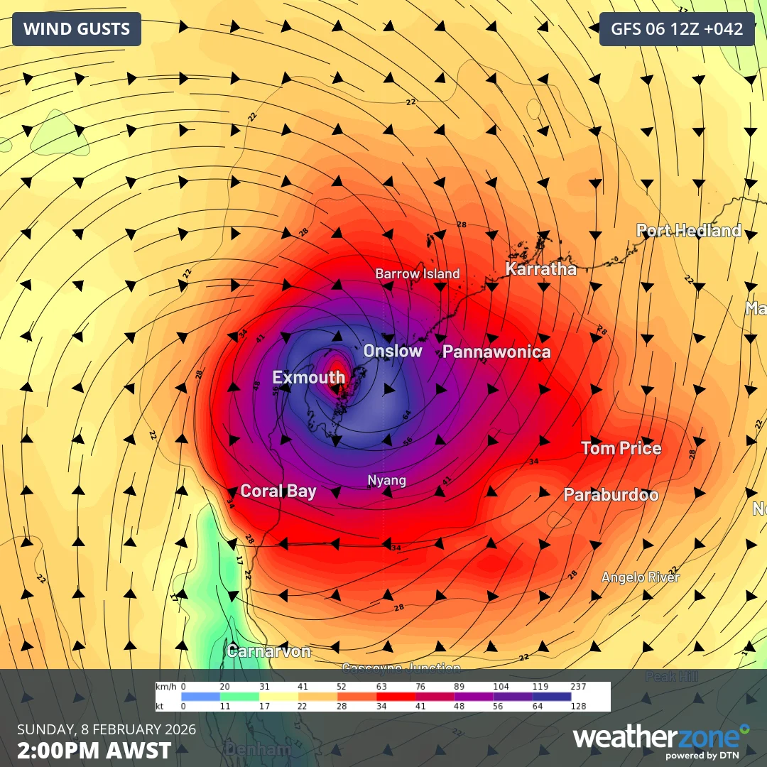
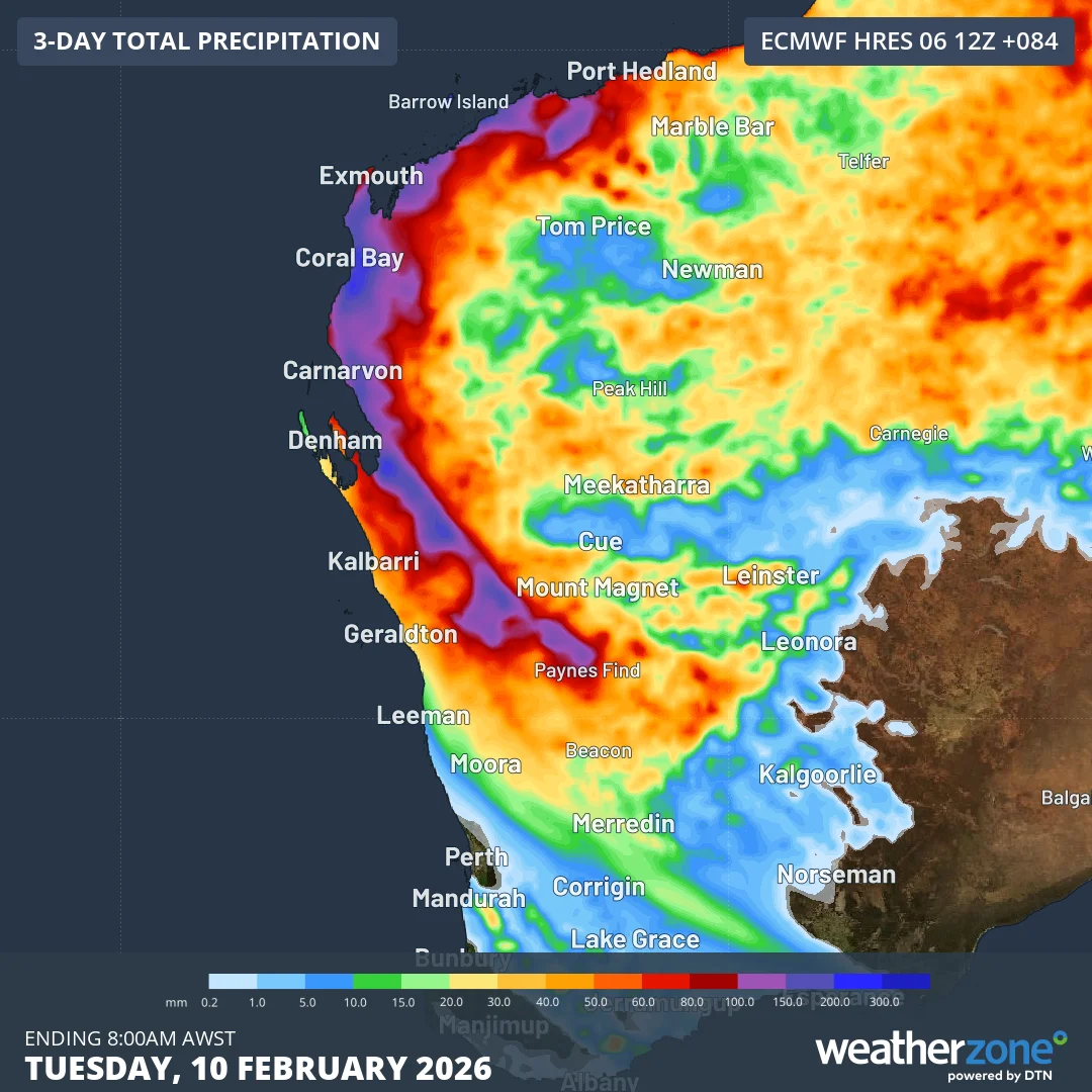
The Bureau of Meteorology (BOM) has been relentless in its advisories, projecting destructive wind gusts potentially reaching 170km/h around Karratha, Dampier, and Wickham, with Onslow and areas further south facing similar threats on Sunday. Warnings extend from De Grey to Ningaloo, encompassing major centres like Port Hedland, Karratha, and Onslow. This isn't just about strong winds; it's about heavy rainfall, dangerous surf, and coastal flooding, with abnormally high tides predicted to exacerbate the situation in Karratha and Onslow. The Department of Fire and Emergency Services (DFES) has issued urgent calls to action, urging residents to monitor the Emergency WA website and to finalize their emergency plans.
Read More: Matt Davidson's June 2023 Art Shows Australian Economy Problems
The Pilbara's Industrial Heart Under Threat
The Pilbara region is not just a collection of towns; it's a vital economic engine for Australia, heavily reliant on its lucrative resources industry. As Mitchell approaches, this crucial sector faces significant disruption. Pilbara Ports have already begun clearing their three major export hubs, a clear indicator of the potential impact on operations.
Economic Vulnerability: The Pilbara's economy is heavily tied to its resource sector.
Infrastructure Risk: Major export hubs are being cleared, anticipating disruption.
Question: What is the long-term economic cost of these increasing weather events on such vital industries? Is our infrastructure resilient enough to withstand prolonged or more frequent severe cyclones?
A Pattern of Escalation? Past Incidents and Current Fears
This isn't the first time Western Australia has faced the wrath of a cyclone. The cyclone season runs from November to April, and residents in the north of the state are acutely aware of the risks. We’ve seen storms like Cyclone Yasi in 2011, which caused widespread devastation across Queensland, and Cyclone Seroja in 2021, which hit the Mid West region of WA with unexpected ferocity, leaving a trail of destruction and power outages. Even the recent extratropical cyclone that impacted the Pacific Northwest in October 2025, causing widespread power outages and significant rainfall, serves as a chilling reminder of nature's escalating power elsewhere.
Read More: March 12th Weather: Snow in Midwest, Rain Elsewhere
Cyclone Yasi (2011): Major devastation in Queensland.
Cyclone Seroja (2021): Unexpectedly severe impact on WA's Mid West.
Pacific Northwest Extratropical Cyclone (Oct 2025): Widespread power outages and flooding.
These past events, while varied in their specifics, share a common thread: the capacity of cyclones to inflict significant damage and disrupt lives. The intensification of Tropical Cyclone Mitchell from a tropical low to a severe category three system raises a critical question: Are the current disaster preparedness measures in WA evolving quickly enough to match the increasing intensity and frequency of these severe weather events?
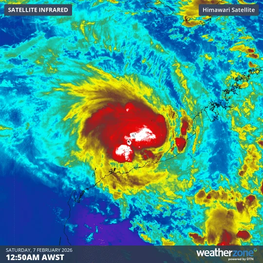
"While this low has been unable to become a tropical cyclone while over land, it has still caused heavy rain over the last few days." – Bureau of Meteorology (via weatherzone.com.au)
This quote from the BOM, referring to the precursor to Mitchell, underscores the significant rainfall impacts even before cyclone formation. It raises a point of concern: are we adequately prepared for the cumulative effects of prolonged heavy rain, not just the immediate impact of destructive winds?
Read More: Western Australia Child Protection Worker Accused of Rape Charges
The Science of Intensification: Why Now?
The BOM's forecasts consistently point to warm ocean waters as a key factor in Mitchell’s rapid intensification. This is not a new phenomenon, but the sustained high sea surface temperatures are a significant characteristic of our changing climate.

| Factor | Description | Implication |
|---|---|---|
| Warm Ocean Water | Tropical cyclones draw energy from warm sea surface temperatures. | Allows for faster intensification and potentially stronger, more damaging storms. |
| Atmospheric Conditions | Specific atmospheric patterns can allow systems to sustain or gain strength. | Favourable conditions can prolong the cyclone's life and increase its impact. |
"Should Mitchell spend more time over warm waters, the system may strengthen further, with category 3 intensity possible before landfall." – weatherzone.com.au
This statement from weatherzone.com.au is crucial. It highlights the duration and proximity to heat sources as critical variables. How often are these "warm waters" now present, and for how long? Are we witnessing a new norm where cyclones are more likely to intensify rapidly and reach higher categories before making landfall?
Evacuating the Vulnerable: A Race Against Time?
The Department of Fire and Emergency Services (DFES) advises that residents may be asked to leave the area before the cyclone arrives, and that airports could be closed. This evacuation process, while necessary, is a complex logistical challenge, especially in remote regions.
Read More: Cuddalore Election and Monsoon Prep: 277 New Booths, Flood Defenses Ready
Warning Zones: Warnings extend from Exmouth to Onslow, and De Grey to Ningaloo.
Preparation Advice: Residents are urged to prepare emergency kits and ensure family members understand their plans.
Emergency Platforms: Emergency WA website and app are key resources for updates and preparation.
The speed at which Mitchell is tracking – described as "pretty fast for a tropical cyclone" in multiple reports – adds another layer of urgency. Does this rapid movement challenge the effectiveness of evacuation orders, potentially leaving less time for people to reach safety? And crucially, what provisions are in place for those who cannot evacuate easily – the elderly, the infirm, or those without the means to travel?
Lessons Unlearned? The Ever-Present Question of Preparedness
As Cyclone Mitchell intensifies and moves closer to the Pilbara coast, the narrative is one of bracing for impact. Residents are stocking up on supplies, sandbagging properties, and heeding official warnings. The DFES and BOM are doing their jobs, providing information and issuing alerts. Yet, a nagging question persists: beyond immediate storm preparations, are we truly learning and adapting from each significant weather event?
Read More: Queensland Flood Deaths: Two Backpackers Found as Major Flooding Continues
Preparedness: Sandbagging, stocking supplies, creating emergency plans.
Information Dissemination: Emergency WA, BOM updates, media alerts.
The Critical Gap: Does preparedness extend to long-term resilience building, infrastructure upgrades, and understanding the evolving threat landscape?
What happens after the winds die down and the waters recede? Are the post-cyclone recovery efforts robust enough? Are we investing in long-term solutions to mitigate the impact of future, potentially more severe, storms? The intensification of Tropical Cyclone Mitchell serves as a stark reminder that while we can forecast the path of a storm, the true test lies in our enduring capacity to withstand and recover from its fury, and to proactively build a more resilient future against the backdrop of a changing climate.
Sources:
Cyclone Mitchell intensifies as towns in north-west WA brace for winds, flooding - The Guardian: https://www.theguardian.com/australia-news/2026/feb/07/cyclone-intensifies-as-towns-in-north-west-wa-brace-for-winds-flooding
Cyclone intensifies as towns brace for winds, flooding - Inkl: https://www.inkl.com/news/cyclone-intensifying-as-towns-brace-for-flash-flooding
Tropical Cyclone Mitchell expected to form off WA's Pilbara coast - ABC News: https://www.abc.net.au/news/2026-02-06/tropical-cyclone-mitchell-forecast-pilbara-kimberley/106310802
Residents readying for wild weather as Tropical Cyclone Mitchell intensifies off WA coast - ABC News: https://www.abc.net.au/news/2026-02-07/wa-pilbara-warnings-cyclone-mitchell/106314534
Tropical Cyclone Mitchell strengthens as Pilbara landfall approaches - Weatherzone: https://www.weatherzone.com.au/news/tropical-cyclone-mitchell-strengthens-as-pilbara-landfall-approaches/1891185
Alert issued for dangerous tropical cyclone off WA coast - PerthNow: https://www.perthnow.com.au/wa/weather/wa-weather-dangerous-tropical-cyclone-warning-issued-for-massive-stretch-of-coastline-c-21541046
Cyclone Overview - Department of Fire and Emergency Services WA: https://www.dfes.wa.gov.au/hazard-information/cyclone
Severe weather update: TC Mitchell to reach the WA coast this weekend - National Tribune: https://www.nationaltribune.com.au/severe-weather-update-tc-mitchell-to-reach-the-wa-coast-this-weekend/
Tropical cyclone to intensify to category 3 storm before it hits WA - 9News: https://www.9news.com.au/national/tropical-cyclone-mitchell-to-intensify-to-category-3-storm-ahead-of-landfall/d71a616f-c028-442f-8117-63bde494c3fe
WA braces for destructive cyclone this weekend - PerthNow: https://www.perthnow.com.au/wa/weather/destructive-winds-flash-flood-warning-as-tropical-low-set-to-turn-into-cyclone-and-hit-pilbara-over-weekend-c-21548529
TC Mitchell to Hit WA Coast This Weekend - Mirage News: https://www.miragenews.com/tc-mitchell-to-hit-wa-coast-this-weekend-1615662/
Locals warned as tropical cyclone strengthens off WA coast - 7NEWS: https://7news.com.au/news/tropical-cyclone-mitchell-tipped-to-strengthen-to-category-3-storm-off-the-coast-of-western-australia-c-21558334
Tropical Cyclone likely to form near WA coast this weekend - Weatherzone: https://www.weatherzone.com.au/news/tropical-cyclone-likely-to-form-near-wa-coast-this-weekend/1891182
Cyclone Warning Issued for North West Coast as Tropical Low Intensifies in Kimberley - SSB Crack News: https://news.ssbcrack.com/cyclone-warning-issued-for-north-west-coast-as-tropical-low-intensifies-in-kimberley/
‘PREPARE NOW’: WA cyclone warning for ‘dangerous’ weather - PerthNow: https://www.perthnow.com.au/wa/weather/cyclone-warning-wa-broome-and-derby-warning-for-dangerous-weather-for-mitchell-plateau-bibyadanga-c-21388611
WA residents prepare for Tropical Cyclone Mitchell - ABC News: https://www.abc.net.au/news/2026-02-07/nauscyclonemitchellwbk0702/106317184
Extratropical Cyclone Whips Over the Pacific Northwest - NASA Science: https://earthobservatory.nasa.gov/images/153605/extratropical-cyclone-whips-over-the-pacific-northwest
Track Cyclone Mitchell live as it approaches WA coast - ABC News: https://www.abc.net.au/news/2026-02-07/cyclone-mitchell-map-tracker-pilbara-wa/106317220


