A disaster declaration now covers Bundaberg as the Burnett River moves toward a peak expected between Tuesday night and Wednesday morning. Upstream at Walla, the gauge hit 19 metres on Tuesday, acting as a blunt forecast for the volume of water moving toward the coast. State officials issued an immediate order for people in Bundaberg North, East, Central, and West to vacate their buildings before the surge arrives.

The ground across Queensland is currently unable to swallow more liquid, with the Bureau of Meteorology noting catchments are saturated.

760 roads are currently broken or blocked by water across the state.
In Mundubbera, the river was timed to cross the 18-metre major flood line on Tuesday afternoon.
The tropical low that caused the initial wreckage has moved into the ocean, but the water it dropped remains trapped in the river systems.
The State as a Map of Blocked Lines
Premier David Crisafulli confirmed that while the rain has eased in some spots, the danger is now a matter of geography and gravity as the runoff migrates through the system. The infrastructure is struggling to hold; hundreds of homes and shops are positioned directly in the path of the inundation.
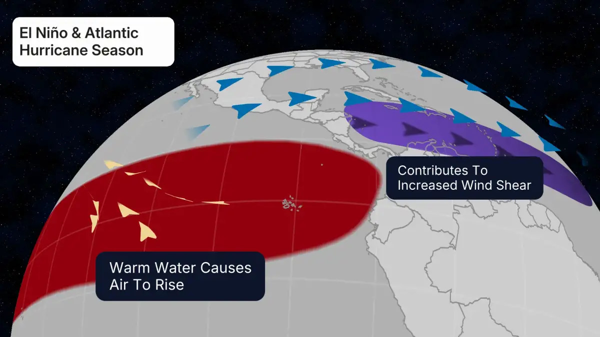
Read More: El Niño May Come to Australia, Weather May Change

| Location | Water Height / Metric | Status |
|---|---|---|
| Walla (Upstream) | 19 Metres | Peak hit Tuesday |
| Mundubbera | 18 Metres | Major flood threshold |
| Bundaberg | Pending | Peak expected Wed morning |
| Statewide Roads | 760 impacted | Significant damage reported |
The current crisis is less about active rainfall and more about the transit of massive volumes of water through saturated soil and overtaxed river banks.

Regional Saturation and Broken Utilities
The flooding in Queensland follows a wider pattern of heavy, unmanaged water across Northern Australia. In the Northern Territory, the town of Katherine recently went through its worst drowning of land in decades. This has created a clogged system where even the utilities are failing.
In Darwin, the Darwin River Dam stopped functioning because it was overwhelmed by the flood, forcing the city to cut back on water use.
Rainfall totals between 50mm and 300mm were recorded in a single week across the Top End and Queensland.
"People in the affected area should follow flood advice and warnings." — Anthony Albanese, Prime Minister.
The bureaucracy of disaster management is now the primary lens through which the town exists. The "disaster" label is a legal tool that allows the state to move people by force and manage the mess. As the tropical low moves offshore, the physical reality for Bundaberg remains a slow-moving wall of river water that has nowhere else to go but through the streets.
Read More: Australia May 2026 budget plans tax changes for property investors