
Rapid Strengthening, Record Temperatures on the Horizon
Ocean temperatures in the tropical Pacific have surged, surpassing critical thresholds and marking the official onset of a "Super El Niño." Experts now forecast that water temperatures will exceed 2°C (3.6°F) above average in key regions driving the El Niño cycle. This rapid intensification is expected to fuel a cascade of extreme weather events worldwide.

The World Meteorological Organization (WMO) predicts the El Niño conditions will mature into a 'strong' event between July and September of this year. Scientists warn that this intensifying El Niño will layer additional heat onto an already warming planet, pushing global temperatures higher across the board in the coming months. The concentration of this warm water acts as a catalyst, capable of raising the global average temperature and significantly disrupting weather patterns on a planetary scale.
Read More: Atlantic Ocean Heat May Cause Super El Niño Event
Global Repercussions: From Droughts to Deluges
El Niño, a recurring climate pattern characterized by unusual warming of surface waters in the central and eastern tropical Pacific Ocean, fundamentally alters atmospheric circulation. This year's iteration is particularly concerning because it arrives on the heels of unprecedented global heat.
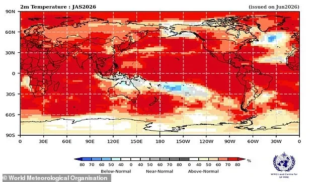
Amplified Climate Change Effects: The combination of a strong El Niño and the background warmth from human-caused climate change is a potent mix. This synergistic effect could lead to weather anomalies that are more severe and unpredictable than in previous El Niño cycles. As one expert noted, "we have never experienced El Niño on a planet already so hot from human-caused climate change."
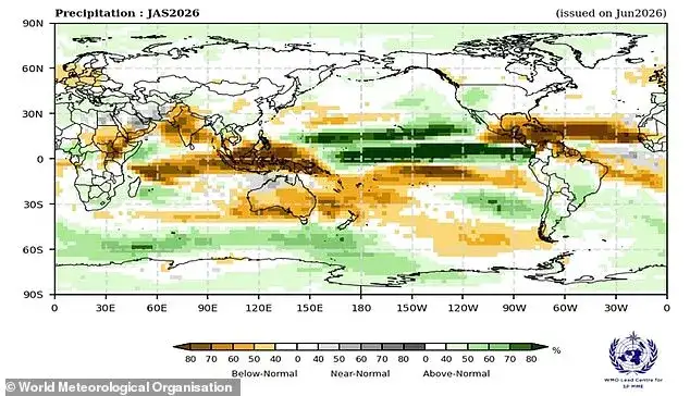
Regional Weather Extremes: Depending on the location, El Niño tilts the odds toward specific climate extremes. This includes widespread heat waves, increased risk of severe drought in some regions, and heightened chances of flooding in others.
Impacts on Asia: South-east Asia faces a significant threat of prolonged, intense heat, severe drought, wildfires, and worsening air pollution. Countries reliant on agriculture, such as Indonesia, Malaysia, Thailand, and the Philippines, are particularly vulnerable. China has already issued warnings for severe rain and storms, anticipating a challenging weather season.
Oceanic Stress: Marine ecosystems are also at risk. Widespread marine heat waves and coral bleaching are anticipated, given corals' extreme sensitivity to rising ocean temperatures.
Regional Variations and Forewarnings
While the overall impact is global, specific regions experience El Niño differently.

United States: The U.S. will see varied effects across its regions.
Caribbean: The Caribbean region often faces drought conditions during El Niño.
Northern Europe: Reduced rainfall is a possibility for Northern Europe, though the influence is considered indirect.
Atlantic Hurricanes: Conversely, stronger El Niño events tend to suppress Atlantic hurricane activity, leading to forecasts of quieter hurricane seasons.
Background: What is El Niño?
El Niño is a naturally occurring phenomenon that typically happens every two to seven years and usually lasts for about a year. It is characterized by a switch in prevailing wind patterns across the tropical Pacific, allowing warmer waters to spread eastward. This redistribution of heat significantly influences global weather systems. This year, however, the development is being closely watched due to the added factor of an already exceptionally warm planet, leading many scientists to anticipate an event that could be among the strongest on record. Some computer models even suggest this year's Super El Niño could be the strongest ever recorded.
Read More: Global Financial System Fragmentation 2026: What It Means For Investors


