A tense situation developed over the Atlantic Ocean and Gulf of Mexico as powerful storms, Tropical Storm Erin and Hurricane Milton, took shape and moved toward land. From the vantage point of space, astronauts and satellites captured striking images and video, showcasing the immense scale and ferocity of these weather systems. These observations provided a unique perspective on the storms' evolution and their potential impact on populated areas, highlighting the importance of space-based monitoring in understanding and preparing for severe weather events.

Storms Emerge Over Atlantic and Gulf
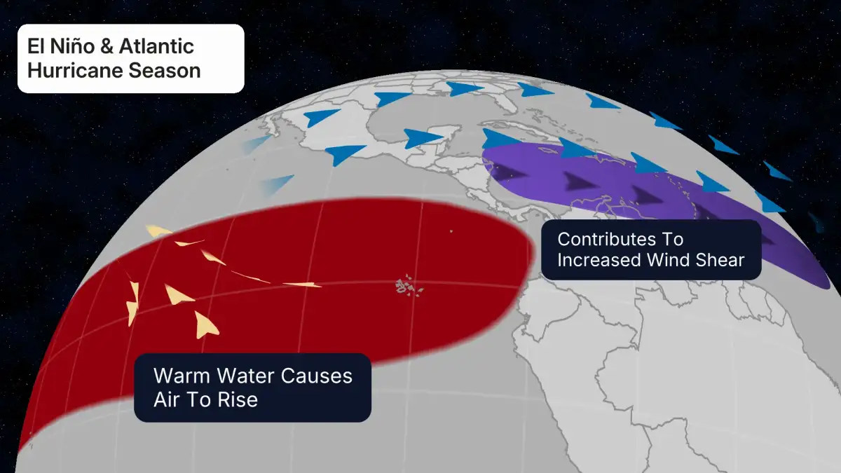
During August 2025 and October 2024, the Atlantic Ocean and Gulf of Mexico became the stages for significant tropical cyclone activity.

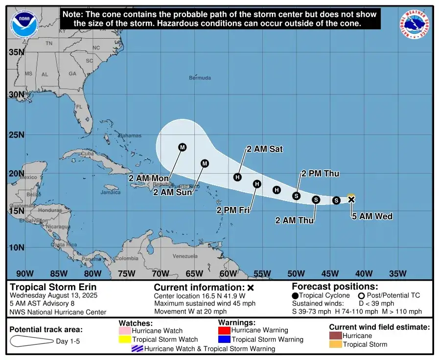
Tropical Storm Erin was first observed taking shape over the Atlantic Ocean in August 2025.
Satellites were instrumental in tracking its development.
Forecasters issued warnings that Erin could intensify into a major hurricane.
Hurricane Milton became a major concern in October 2024, particularly as it approached Florida.
The storm reached Category 5 status, signifying extreme winds and the potential for catastrophic damage.
It was forecast to make landfall on Florida's Central Gulf coast.
Space-Based Observation Capabilities
The ability to monitor these storms from space has been crucial for understanding their development and providing vital information.

Satellites continuously track the formation and strengthening of tropical systems like Erin.
They offer a broad view of the storm's structure and movement.
The International Space Station (ISS) provided a unique and close-up perspective.
Astronauts aboard the ISS captured timelapse videos and images of Hurricane Milton.
These visuals offered an unprecedented perspective on the storm's sheer size and visual appearance.
Cameras on the ISS operate at extremely high speeds, with the station itself orbiting the Earth at approximately 17,500 mph.
Hurricane Milton: A Visual Record from Orbit
Hurricane Milton’s approach to Florida was documented extensively from the ISS, offering a stark visual representation of its power.
Read More: Lab Recreates Dying Stars, Shows Hydrogen Makes Life's Building Blocks

Visual Documentation: Stunning footage and images of Milton were shared by NASA astronauts.
Matthew Dominick, a NASA astronaut, shared a timelapse video of the hurricane.
These visuals showcased the storm's massive scale as it moved across the Gulf of Mexico.
Storm Intensity: Milton fluctuated between Category 4 and 5 status while over the Gulf.
On October 9, 2024, it was a Category 3 storm with maximum sustained winds of 120 mph when nearing landfall.
The Saffir-Simpson Hurricane Scale defines Category 5 as winds of 157 mph or higher, capable of causing catastrophic damage.
Landfall Predictions: Milton was expected to make landfall on Wednesday night, likely as a Category 3 storm.
Specific predictions placed landfall near Sarasota, Florida.
After landfall, the storm was expected to weaken rapidly over land but maintain hurricane status initially.
Tropical Storm Erin: Early Development from Space
Tropical Storm Erin, observed in August 2025, also benefited from space-based monitoring during its formative stages.
Tracking Formation: Satellites were employed to observe Erin as it steadily gathered strength over the Atlantic.
Video Evidence: A video documented the storm's emergence from space, offering views of its developing structure.
Potential for Intensification: Forecasters noted the possibility of Erin strengthening into the season's first major hurricane within days of its initial tracking.
Hurricane Hunter Collaboration: Incredible views of Erin were also captured by satellites and the United States Air Force's Hurricane Hunters, offering complementary data.
The Significance of Space-Based Hurricane Imagery
The images and videos captured from space offer more than just visual records; they are critical tools for scientific understanding and public awareness.
Scale and Power: The visuals from space emphatically demonstrate the immense scale and power of hurricanes.
Hurricane Milton, in particular, was described as looking like something from a "dystopian film" due to its size.
Forecasting Support: Continuous observation from satellites aids meteorologists in tracking storm movement and intensity, crucial for evacuation orders and preparedness.
Public Awareness: Dramatic footage can underscore the severity of approaching storms, prompting necessary action from residents in affected areas.
Millions of people were compelled to evacuate Florida in anticipation of Hurricane Milton.
Expert Perspectives and Data
While direct quotes from specific experts on these particular storms were not extensively detailed in the provided summaries, the context implies the reliance on established meteorological and astronautical bodies.
NASA's Role: NASA astronauts and cameras aboard the ISS were central to documenting Hurricane Milton.
Forecasting Agencies: Agencies like the National Hurricane Center (implied by the nature of the warnings) provide the analysis of storm intensity and trajectory.
Satellite Technology: The ongoing development and deployment of advanced satellites are foundational to the observation of weather systems globally.
Conclusion and Implications
The events surrounding Tropical Storm Erin and Hurricane Milton underscore the vital role of space-based observation in tracking and understanding severe weather. The ability of satellites and astronauts on the ISS to capture detailed imagery and data provides invaluable insights into the formation, intensification, and movement of hurricanes.
Enhanced Monitoring: The comprehensive visual records of these storms offer a clear testament to the capabilities of modern space technology in weather science.
Preparation and Response: Such observations directly inform disaster preparedness efforts, enabling timely warnings and evacuations that can save lives and mitigate damage.
Future Research: The data collected from these events will likely contribute to ongoing research aimed at improving hurricane prediction models and understanding the complex dynamics of these powerful storms. The contrast in timing between Erin (August 2025) and Milton (October 2024) also highlights the cyclical nature of hurricane seasons and the persistent need for vigilant monitoring.
Sources
Space.com: Satellites watch Tropical Storm Erin take shape over the Atlantic Ocean (video)
Published: Aug 13, 2025
Space.com: Fly through the eye of Hurricane Erin and see the powerful storm from space (video)
Published: Aug 19, 2025
Newsweek: NASA captures astonishing footage of Hurricane Milton from space
Published: Oct 9, 2024
Link: https://www.newsweek.com/nasa-captures-astonishing-footage-hurricane-milton-space-1966327
ABC7 News: This is what monstrous Hurricane Milton looks like from the space station
Published: Oct 9, 2024
Link: https://abc7news.com/post/hurricane-space-is-what-monstrous-milton-looks-like-station/15409523/
CBS News: Stunning images show Hurricane Milton from space
Published: Oct 9, 2024
Link: https://www.cbsnews.com/news/hurricane-milton-photos-space/
PetaPixel: Hurricane Milton's Insane Scale As Seen From Space
Published: Oct 8, 2024
Link: https://petapixel.com/2024/10/08/hurricane-miltons-insane-scale-as-seen-from-space/
Ladbible: Terrifying footage shows NASA astronaut recording what hurricane looks like from space
Published: Oct 9, 2024
Link: https://www.ladbible.com/news/us-news/nasa-astronaut-hurricane-milton-footage-space-994351-20241009