
Monitoring how countries grow and use their resources is a difficult task. Traditionally, the world has relied on reports provided by national governments. However, recent evidence suggests that these reports do not always show the full picture. Using high-resolution satellite imagery and machine learning, researchers have begun to identify significant gaps in what is known about global activity. These tools allow for the observation of regions where data is missing, either due to a lack of resources or intentional secrecy. Investigations now show that human activity—from industrial fishing to city expansion—is much larger than previously recorded. This development provides a more accurate view of the world, but it also raises questions about why certain data remains hidden from public view.
Timeline of Observations and Key Actors
The use of these technologies has moved from laboratory tests to active monitoring over the last few years. Several organizations have led this effort to verify ground-level data from space.
Read More: Palantir CEO: LLM companies care more about money than users
2022: Research highlighted the potential for AI to measure poverty and development where traditional surveys were missing. Organizations like Brookings and journals like Science began documenting how autocratic regimes often collect less data.
2023: The OECD began using AI models to monitor land use across metropolitan areas, comparing city growth to actual population trends.
2024: A major study by Global Fishing Watch published in Nature revealed that three-quarters of the world's industrial fishing vessels are not publicly tracked.
2025: NASA and the USGS advanced their systems to make satellites "smarter," using AI to skip over cloud cover and automatically label land use changes in real-time.
Evidence of the "Hidden" Economy and Environment
The data collected shows a clear difference between official records and physical reality. This is most visible in the maritime and urban sectors.
"Analysis reveals that about 75 percent of the world’s industrial fishing vessels are not publicly tracked, with much of that fishing taking place around Africa and south Asia." — Global Fishing Watch Report
| Sector | Reported Data | Satellite/AI Finding |
|---|---|---|
| Industrial Fishing | Publicly tracked vessels | 75% of vessels are "dark" or untracked |
| Shipping/Energy | Port and transport logs | Over 25% of activity is missing from systems |
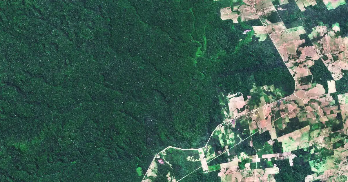
| Land Use | National land registries | AI now detects annual changes in forests and fields |
| Economic Development | Government census data | New models use Wikipedia and light patterns to estimate wealth |
The Gap Between Official Data and Satellite Reality
There is a growing discussion regarding why national data often fails to match satellite observations.
Industrial Activity at Sea
Research shows that a massive amount of human activity in the ocean is invisible to standard tracking systems. While some vessels do not have the technology to be tracked, others may intentionally turn off their signals. This occurs most often near Africa and South Asia.
On one hand, this lack of data might be due to a lack of infrastructure in developing nations.
On the other hand, the data suggests that these "dark" vessels may be encroaching on small-scale fishing grounds or participating in illegal activity.
Is the lack of tracking a sign of poor technology, or is it a tool for avoiding environmental laws?
Monitoring Development in Restricted Areas
In regions like North Korea, gathering economic data is nearly impossible through traditional means. Investigators have used satellite imagery combined with geolocated information from the internet to estimate development.
Some researchers argue that satellite data is the only objective way to see if a country is actually growing.
Others point out that AI models can be "noisy" or incorrect if they are not trained with enough local knowledge.
Is it possible to truly understand a nation's economy without any data from the people living there?
Agricultural and Climate Action
In West Africa, satellite data is being used to help farmers manage salt flow in irrigation and predict crop yields. This is intended to reduce the need for food imports.
Read More: Study: People Cooperate More Than They Think Others Do
Supporters say this technology turns Africa into a "breadbasket" by providing data that governments cannot provide.
Critics note that while monitoring is good, it has not yet led to a full shift in how the land is managed. The leap from "watching" to "fixing" remains a challenge.
Technical Constraints and Explainability
Despite the speed of AI, there are significant limits to how much we can trust the results without human oversight.
1. The "Black Box" ProblemResearchers at ScienceDirect have noted that it is often hard to understand why an AI model makes a certain decision. If an AI says a region is "poor," we need to know if it is looking at the roofs of houses, the lack of roads, or the absence of lights. Without this "explainability," leaders are hesitant to use the data for big policy changes.
2. Data Quality IssuesModels trained on "noisy" or messy data perform poorly. If a government provides bad data to start with, the AI may learn the wrong patterns.
Does the use of AI actually fix bad data, or does it just repeat the mistakes of the original source faster?
3. Autocratic Data GapsThere is a documented trend where less-democratic governments collect and share less information. Satellite imagery acts as a check on this, but it cannot always explain why certain buildings are being built or why certain resources are being moved.
Read More: New GPU Cooler Handles 1000W Power in London
Expert Analysis
The Role of Automation:According to Rylie Fleckenstein (USGS), AI is now used for both labeling land cover and detecting yearly changes. This is much faster than human interpretation, which was the standard in the past. This speed allows for "anticipatory action" before environmental damage becomes permanent.
The Accuracy of Remote Sensing:NASA researchers emphasize that "Dynamic Targeting" allows satellites to make their own decisions in seconds. By avoiding clouds, satellites provide more "valuable science data" than they did when they simply looked straight down at all times.
The Development Promise:The Brookings Institution suggests that while satellite data is only "one piece of the puzzle," it is essential for meeting Sustainable Development Goals (SDGs) because it provides a baseline that cannot be easily manipulated.
Read More: N. Ravi Calls for Media Freedom Environment in 2026
Conclusion
Current evidence shows that satellite imagery and AI have moved beyond simple map-making. They are now investigative tools that reveal hidden industrial fishing, undocumented urban growth, and the economic status of closed societies.
Key Findings:
Hidden Footprint: A large portion of global industrial activity, especially at sea, is not recorded in public logs.
Speed vs. Accuracy: AI can process data much faster than humans, but it remains sensitive to "noisy" information and lacks the ability to explain its reasoning in a way that all policymakers trust.
Policy Gaps: Monitoring has improved, but using this data to change how resources are managed on the ground is still a developing process.
Next Steps:
Further integration of "explainable AI" is needed to make satellite findings useful for lawmaking.
International partnerships are required to address the 75% of "dark" fishing vessels identified by researchers.
Investigation continues into how AI can be trained to recognize development without relying on potentially biased national datasets.
Primary Sources
Global Fishing Watch (2024): On the hidden footprint of human activity at sea.Link
Brookings Institution (2022): Using satellites and AI to fix development data.Link
NASA (2025): Advancements in smarter Earth-observing satellites.Link
OECD Statistics (2023): Monitoring urban transformation with AI.Link
Science (2022): On the impact of noisy data and autocratic data collection.Link
ScienceDirect (2022): Review of explainable AI in human poverty domains.Link
USGS (2025): AI improving science and land cover labeling efficiency.Link


