
Unpredictable skies have brought dust storms, fierce winds, and rain to Delhi-NCR, with the meteorological department issuing varied alerts.
The region has experienced a confluence of erratic weather phenomena. Dust storms and strong winds have swept across Delhi and Noida, creating reduced visibility. Concurrently, the Indian Meteorological Department (IMD) has been issuing alerts for rain and thunderstorms, with a yellow alert anticipated for the upcoming weekend.

Recent weather shifts include dust storms and strong winds impacting visibility, alongside warnings of rain and thunderstorms. Temperatures, despite the recent precipitation, are still expected to remain above normal. This unseasonal atmospheric activity is attributed by meteorologists to a 'Western Disturbance' affecting northwest India.

Meteorological Forecast and Alerts
The IMD has navigated a landscape of varied alerts. Earlier warnings included an orange alert for Tuesday evening, anticipating thunderstorms, rain, lightning, and dust storms. This has been followed by a consistent issuance of yellow alerts for different days, signaling potential light rain, thunderstorms, lightning, and gusty winds across Delhi-NCR. The alerts span across cities like Noida, Gurugram, and Ghaziabad.
Read More: Rain May Stop Katherine Legge's 1100-Mile Race Goal This Weekend
Current Alerts: Yellow alerts have been prominent for days, indicating a watchful stance for unpredictable weather.
Past Warnings: An orange alert was issued, signaling a higher probability of severe weather events.
Forecasted Conditions: Light rainfall, thunderstorms, and gusty winds are expected to continue impacting the region.
Observed Weather Events and Impacts
The weather has not merely been a forecast. Various parts of Delhi-NCR have directly experienced the brunt of these changes.

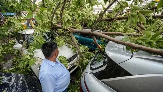
Dust Storms and Winds: Reports indicate significant dust storms and winds reaching speeds of 30-40 kmph, with gusts up to 50 kmph in some areas. This has led to visibility dropping below 500 meters on certain routes, like the Delhi-Jaipur Expressway. In Noida, strong winds have reportedly toppled trees, poles, and sheds, and in Delhi's Connaught Place, an uprooted tree damaged vehicles. Some incidents suggest injuries and flight diversions due to these conditions.
Rainfall: Light to moderate rain has been recorded across various monitoring stations in Delhi, including Safdarjung and Palam. While offering some respite, it has occurred alongside daytime temperatures that remain elevated.
Temperature Fluctuations: Despite the incoming rain, daytime temperatures have been noted to hover around 33 degrees Celsius, with some areas experiencing highs around 42-44 degrees Celsius, often remaining above normal. Conversely, some reports mention temperatures dipping to 27-29 degrees Celsius during rain spells.
Underlying Causes and Broader Context
Meteorologists point to a 'Western Disturbance' as a primary driver of this unseasonal weather. This atmospheric phenomenon, moving across northwest India, is bringing about the current convective activity. Historically, March has seen a range of weather extremes, from heatwaves with temperatures around 34.8°C to unseasonal rain and dust storms that can disrupt daily life, as observed in past events including those from March 2025 and 2026. The recurrence of these events, particularly dust storms, has also been linked to dust advection from regions like North Pakistan, moving via Punjab and Haryana.


